Slaughter Lane
Client: City of Austin
City: Austin
State: Texas
Services: Public Works
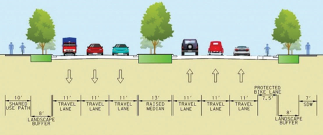
Slaughter Lane is a major arterial road located in south Austin. The Slaughter Lane Corridor Mobility Plan limits are between FM 1826 and Vertex Boulevard and extend approximately 10.6 miles. There are 56 intersections within the boundaries of the corridor plan area, 28 of which are signalized. This corridor provides access to residences and businesses, as well as commuters traveling through the area. Changes in the existing context of Slaughter Lane were evaluated in terms of existing land use and character.
BGE proposed several improvements to the Slaughter Lane Corridor Mobility plan in the Preliminary Engineering Report, including 28 traffic signals with enhanced technology to promote vehicular and transit efficiency and pedestrian and bicyclist safety. The project consisted of modifying turn lanes to enhance vehicular and transit efficiency and pedestrian and bicyclist safety at Escarpment Boulevard, Brodie Lane, South Congress Avenue and IH-35. BGE designed six miles of new or rehabilitated sidewalks to create continuous ADA-compliant sidewalks along the length of the corridor. The design added 14 miles of buffered and protected bike lanes to improve safety and mobility for bicyclists and drivers. Our team evaluated new mid-block pedestrian crosswalk signals (Pedestrian Hybrid Beacons) for cyclists and pedestrians on Zuniga Drive, Briar Ridge Drive, Vinemont Drive and Narrow Glen Parkway. BGE engineers coordinated with Capital Metro on transit facility improvements, including relocation of bus stops to the far side of the intersection to improve safety and operations for both transit and vehicles, adding bus shelters and benches and bus pull-outs at transfer centers.